
A hidden utility can turn a clean bore path into a major jobsite emergency. A utility line locator helps crews find buried gas, water, sewer, electric, and communication lines before horizontal directional drilling begins.
Directional drilling reduces open-trenching, but the drill head still passes through crowded soil where old and new utilities may cross the route. Superior Scanning helps contractors use utility locating services, underground utility mapping, and field markings to plan safer bore paths before the drill launches.
Table of Contents
Don’t Cut, Core, or Drill Blind
Superior Scanning is trusted on complex job sites
Why Is Directional Drilling So Risky?
Directional drilling is risky because the drill travels underground, where crews cannot see buried obstacles directly. The operator can track the drill head, but that does not mean every pipe, cable, or conduit in the path is visible.
A skilled utility locator helps reduce that blind spot. Accurate utility locating gives the drill crew better information before the bore path reaches a gas line, fiber route, sewer lateral, or pressurized water main.
Blind Drilling Trajectories
Blind drilling trajectories create risk because the drill head follows a planned path through soil that may contain unmarked utilities. Old records can be incomplete, and private lines may not appear on public marks.
A utility line locator checks the route before work begins. That extra step helps crews adjust the bore path, confirm clearance, or pause for verification in high-risk areas.
High-Density Utility Corridors
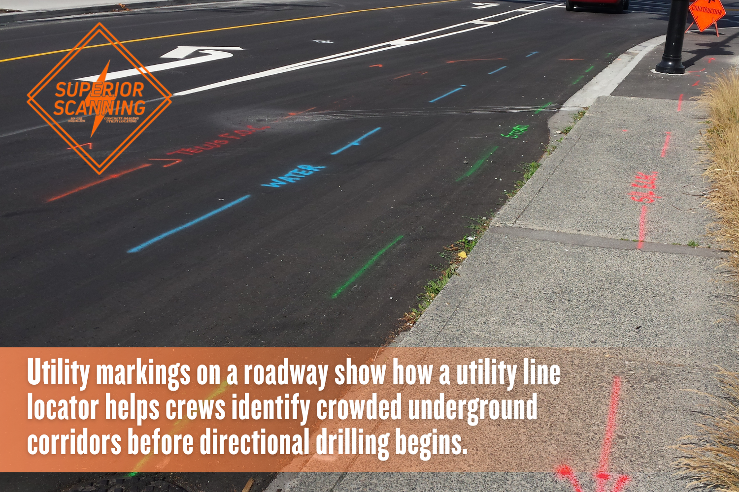
High-density utility corridors are common near roads, commercial sites, campuses, and older properties. Several lines may run close together, especially where water, sewer, gas, electric, and communication services enter a property.
Underground utility locating services are especially valuable in these areas. When the corridor is crowded, even a minor routing mistake can cause an outage, a repair bill, or a safety issue.
What Accidents Happen Most Frequently?
The most common directional drilling accidents involve utility strikes, cross-bores, service outages, and damaged private lines. These problems often occur when crews rely solely on old drawings or incomplete surface marks.
Failing to secure advanced utility mapping before starting a trenchless project can lead to serious site accidents:
- High-voltage electrocution from contact with buried electrical cables
- Cross-boring through sewer lines, which can create hidden safety risks later
- Fracturing pressurized water mains and flooding the work area
- Striking gas lines, which may trigger evacuations and emergency response
- Cutting fiber optic lines and shutting down the internet or communication service
- Damaging irrigation, lighting, or private site utilities not covered by public marks
- Breaking storm drains or sewer lines that affect drainage and sanitation
- Hitting abandoned conduits that block the drill path and force delays
A professional locate does not remove every risk, but it gives the crew a better plan. That matters when drilling happens below pavement, landscaping, buildings, or active traffic areas.
How Does a Utility Line Locator Prevent Strikes?
A utility line locator helps prevent strikes by finding and marking underground utilities before drilling starts. The process gives project teams a clearer map of likely conflicts along the proposed bore route.
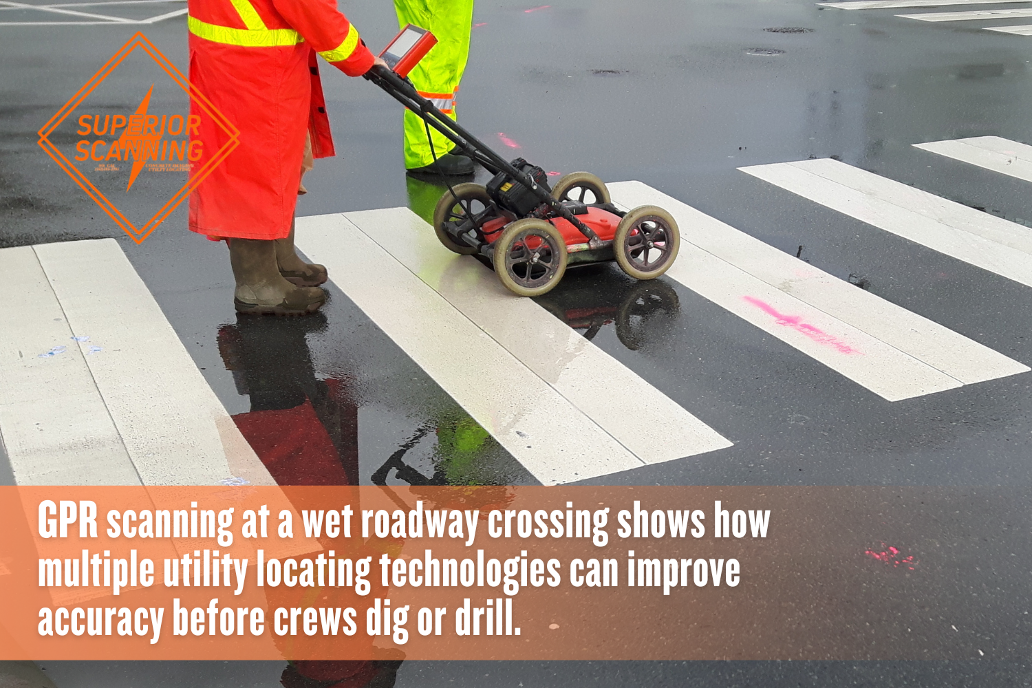
Comprehensive utility locating services often combine multiple methods. That matters because pipe material, depth, soil condition, and surface access can change what each tool can detect.
Active Electromagnetic Indication
Active electromagnetic indication uses a signal to help trace conductive utilities, such as metal pipes, tracer wires, and certain cables. The locator follows the signal above ground and marks the likely route for the field crew.
This method works well when a line can carry or receive a signal. It may not fully trace plastic, concrete, or non-conductive lines without tracer wire, so the locator may need added tools for confirmation.
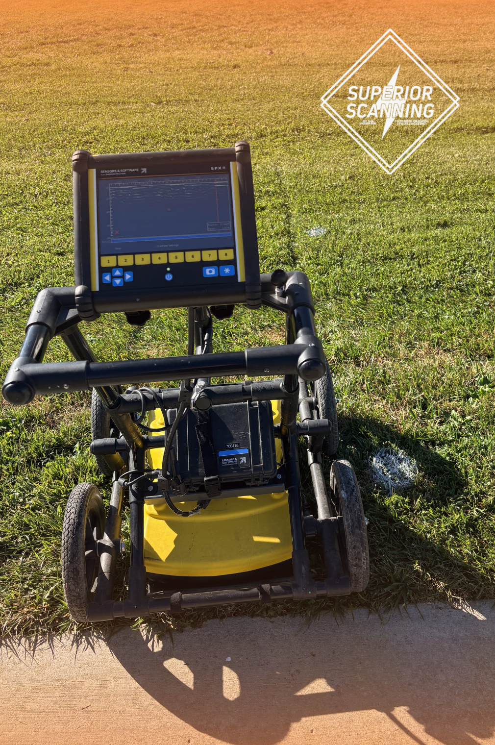
Ground Penetrating Radar Validation
Ground Penetrating Radar (GPR) validation sends radar signals into the ground and reads reflections from buried objects or subsurface changes. It can help identify certain non-metallic utilities, voids, and buried features when site conditions allow.
GPR is not magic, and results can vary with soil, moisture, depth, and surface type. A careful utility locator uses it, along with field experience, records review, and visible site clues, to build confidence.
Don’t Cut, Core, or Drill Blind
Superior Scanning is trusted on complex job sites
Which Technologies Improve Locate Accuracy?
Locate accuracy improves when professionals use multiple tools rather than relying on a single method. A single device may miss a line, especially when utilities are deep, non-metallic, or close to other buried systems.
The most reliable private utility locating companies near you combine several specialized tracking systems:
- Utility mapping software to organize field marks, route notes, and site data
- Dual-frequency pipe locators for tracing different conductive lines
- Ground Penetrating Radar (GPR) for certain buried objects and non-metallic utilities
- Electromagnetic locators for cables, tracer wires, and metallic pipes
- Vacuum potholing tools to expose key utilities when visual confirmation is needed
- Site records review to compare old plans with field conditions
- Global Positioning System (GPS) equipment to document mapped utility routes when needed
- Clear surface markings using paint, flags, or stakes for the drilling crew
Choosing private utility locating services should involve more than getting a quick markout. The better choice is a team that explains limits, documents findings, and helps crews plan around uncertainty.
When Should Teams Update Underground Utility Mapping?
Teams should update underground utility mapping before the final bore path is approved and again when site conditions change. Fresh data matters because buried utilities can be added, repaired, abandoned, or moved based on what older records show.
Outdated plans can create a false sense of safety. Underground utility locating services should be part of pre-bore planning, not a last-minute step after equipment is already staged.
Pre-Bore Route Clearance
Pre-bore route clearance should happen before drilling equipment begins work. The utility line locator reviews the planned path, checks visible utility features, scans the area, and marks likely conflicts.
This step gives the project team time to make changes without rushing. A small route adjustment before drilling can prevent a costly strike after the drill head is already underground.
Real-Time Mapping Updates
Real-time mapping updates help when crews discover new information during the job. A pothole, exposed pipe, old valve, or unexpected mark may change the safest bore path.
Good utility mapping stays useful in the field because it can be updated as conditions become clearer. That keeps supervisors, drill operators, and spotters working from the same information.
Don’t Cut, Core, or Drill Blind
Superior Scanning is trusted on complex job sites
Frequently Asked Questions
What is a utility line locator?
A utility line locator is a trained professional or a tool used to find and mark buried utilities before excavation, trenching, or directional drilling.
How accurate are underground utility locating services?
Underground utility locating services can be highly useful, but accuracy depends on soil type, depth, pipe material, records, and the methods used.
Why is cross-boring a major risk in directional drilling?
Cross-boring is a major risk because a new bore can pass through an existing sewer, gas, or utility line without being noticed right away.
Does 811 mark private utilities along a drill path?
811 helps notify public utility owners, but private utilities along the drill path may need separate utility-locating services.
How do professional utility locating services track plastic pipes?
Professional utility locating services may use Ground Penetrating Radar (GPR), tracer wire, records, surface clues, or potholing to help track plastic pipes.
How Will You Secure the Next Bore Path?
Securing the next bore path starts with accurate utility locating before the drill launches. A reliable utility line locator, updated underground utility mapping, and careful utility mapping help crews avoid buried hazards that can stop work, damage infrastructure, or create serious safety risks.
Superior Scanning supports contractors with underground utility locating services that help confirm site conditions before directional drilling begins. Map the route early, identify the risky areas, and provide the drilling crew with a safer path from the entry pit to the exit point.
