
Don’t Cut, Core, or Drill Blind
SuperiorGPR is trusted on complex job sites
What Is a Utility Survey?
A utility survey is a highly detailed investigation that locates and maps buried pipes, cables, and wires. Construction planners rely on this exact data long before they begin major site changes. Having a clear picture of the underground landscape prevents dangerous accidents.What Does a Utility Survey Look For?
Investigators hunt for hidden water mains, high-pressure gas lines, electrical cables, telecom wires, and sewer pipes. Pinpointing these services early prevents sudden utility shutoffs and keeps the surrounding neighborhood running without interruption.What Is an Underground Utility Survey?
Industry professionals often use the term “underground utility survey” to describe the process of identifying infrastructure below grade. The primary goal remains exactly the same. Field teams just want to find hidden hazards before the buckets hit the dirt.Why Is a Utility Survey Important?
Guessing the location of buried pipes puts the entire crew in danger and threatens the project timeline. Taking the time to properly map the site prevents disastrous accidents during deep excavation work. Accurate ground data ultimately saves contractors significant time and money.How Can a Utility Survey Help Reduce Safety Risks?
Spotting lines early drastically reduces the risk of utility strikes. This directly reduces the risk of injury to the equipment operator and the ground crew. Proper awareness before digging ensures everyone leaves the job site safely.How Can a Utility Survey Help Save Time and Money?
Reliable field data translates to less rework and fewer unexpected delays. Crews plan daily tasks better when everyone knows what lies ahead. Avoiding unexpected damage keeps the overall project budget firmly on track.
How Does a Utility Survey Work?
A proper investigation follows a strict sequence to ensure no buried line goes unnoticed. Field technicians gather historical data and deploy advanced scanning tools to build a comprehensive picture of the property. The process moves logically from initial planning to final mapping.What Happens Before the Survey Starts?
The team starts by reviewing any available municipal plans and conducting a visual site walk. Investigators look closely for surface clues, such as manhole covers, patched asphalt, or utility meters, to clearly define the scope of work.What Happens During the Survey?
Technicians actively scan the soil, trace the signals, and mark the hidden utilities directly on the ground using bright paint. They cross-check these fresh findings against old records to verify accuracy.What Happens After the Survey Is Finished?
The client receives highly accurate utility mapping files along with a detailed record of the marked findings. The project team uses these deliverables to plan safer excavation routes.What Tools Are Used in a Utility Survey?
Field professionals use specialized equipment to effectively locate various types of buried materials. A thorough investigation combines records research, surface geophysics, and physical digging rather than relying on a single gadget. The primary tools used include:- Electromagnetic Locators: Technicians use these wands to trace conductive materials, such as metal pipes and live electrical cables, by detecting specific signals to pinpoint their exact horizontal surface location.
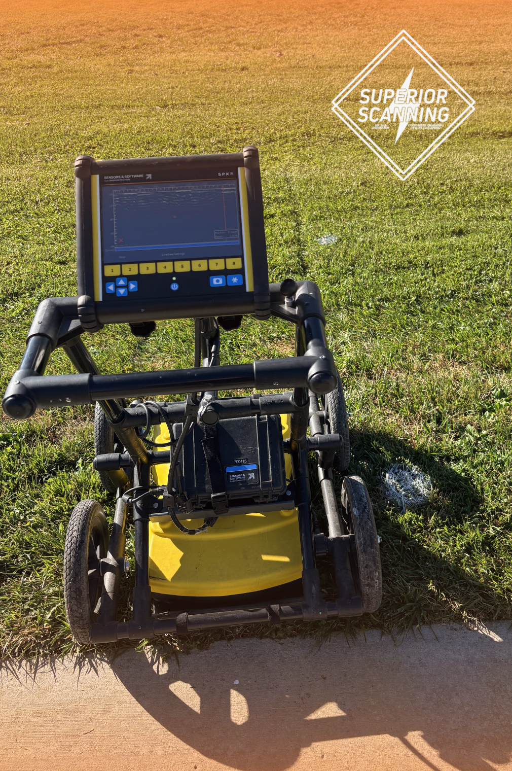
- Ground Penetrating Radar (GPR): Radar units send signals into the earth to bounce off buried objects. This method serves as a primary scanning process and works exceptionally well when local soil conditions allow for deep signal penetration.
- Vacuum Excavation: This safe “potholing” technique is used to physically expose and visually confirm a specific utility line, providing absolute certainty regarding the exact depth and size of a critical pipe.
Don’t Cut, Core, or Drill Blind
SuperiorGPR is trusted on complex job sites
What Is the Difference Between a Utility Survey and Utility Mapping?
Construction teams often confuse utility surveying and mapping, but understanding their distinct roles helps project managers coordinate much more effectively.| Feature | Utility Survey | Utility Mapping |
|---|---|---|
| Primary Action | The actual physical investigation happening out in the dirt. | The final drafted document created from the gathered data. |
| Deliverable | Physical paint marks left directly on the ground. | A digital map or recorded document (often viewed on a tablet). |
| Main Audience | The field crew actively executing the physical work. | Project managers and the office team for long-term coordination. |
What Is the Difference Between 811 and a Utility Survey?
While calling the national 811 dig line is legally required before breaking ground, it rarely tells the whole story about a property, making a private utility survey essential for commercial projects.| Feature | 811 (Public Locating) | Private Utility Survey |
|---|---|---|
| Coverage Limits | Focuses exclusively on public lines leading right up to the service meter. | Maps out everything past the meter, including internal networks and parking lot lighting. |
| What Gets Marked | Only the specific municipal infrastructure that public utility companies actively maintain. | All privately owned underground infrastructure held by the property owner. |
| Project Role | Satisfies basic, legally required pre-dig procedures. | Fills in dangerous blind spots to create a complete, safe site plan for commercial projects. |
What Can a Utility Survey Help You Avoid?
Skipping the investigation phase exposes the job site to significant financial risks. Securing clear data helps contractors dodge the most common and expensive construction pitfalls.Can a Utility Survey Help Prevent Utility Strikes?
Yes, mapping the site drastically reduces the guesswork before digging begins. Excavator operators know exactly where to steer the buckets to avoid causing a dangerous, high-pressure strike.Can a Utility Survey Help Prevent Delays and Change Orders?
Yes, having accurate ground data improves daily planning and prevents surprise conflicts. The crew avoids expensive change orders because the team already knows what hides just below the surface.When Should You Schedule Utility Survey Services?
Booking utility survey services at the right time keeps complex projects moving smoothly. Smart project managers gather this data weeks before the heavy equipment arrives. Certain phases of construction demand an immediate inspection:- Before Excavation: Critical when historical ground conditions are unclear, ensuring crews do not dig blindly and shatter essential utilities like water mains.
- Before Site Changes or Renovations: Essential for major renovations, as forgotten buried lines often dictate the new design scope and force architects to adjust the final building layout.
- Before Trenching or Utility Relocation: Necessary to map a clear path, significantly reducing the chance of your new trench accidentally intersecting with dangerous, high-voltage cables.
What Should You Look For in Utility Survey Services?
Not all companies provide the same level of detail or communication. Contractors need a partner that delivers actionable, easy-to-read data. A few key factors make a locating service truly valuable in the field.What Makes Utility Survey Services More Useful on a Job Site?
Construction crews need clear ground markings, honest communication, and highly detailed documentation to succeed. Fast turnaround times on the final reports also keep the master schedule from stalling.What Should You Expect From a Utility Survey Company?
Clients should expect field-ready results and significantly better visibility into complex buried conditions. A strong locating partner provides the direct support needed for confident planning and safer physical execution.
When Should You Call a Professional Like Superior Scanning?
Complex sites require technicians who can interpret messy ground signals. Bringing in a seasoned expert ensures the crew receives reliable markings rather than dangerous guesses.What Are the Signs You Need a Professional Utility Survey?
Call an expert if the old blueprints seem inaccurate or if the site features a dense network of private utilities. Professional help is mandatory when a utility strike could pose major safety risks to the surrounding community.Why Call Superior Scanning for a Utility Survey in Southern California?
Superior Scanning provides advanced GPR concrete scanning, private utility locating, and utility mapping across Southern California. The goal is always to support safer, faster job-site decisions. Field technicians deliver clear markings, prompt reporting, and real support for contractors working across Los Angeles, Orange County, Riverside, and San Diego.Don’t Cut, Core, or Drill Blind
SuperiorGPR is trusted on complex job sites
