 Skip to content
 What Are the Immediate Physical Deliverables Left on the Job Site?
Long before a formal document lands on your desk, you get results right on the slab. The first phase of deliverables happens in real time. Technicians process the concrete ground-penetrating radar (GPR) data directly on the floor to provide clear signals for your coring team. These visual cues allow workers to see exactly where hazards hide before any digital files are even processed. It is all about giving your crew actionable information the moment the scanner passes over the floor.
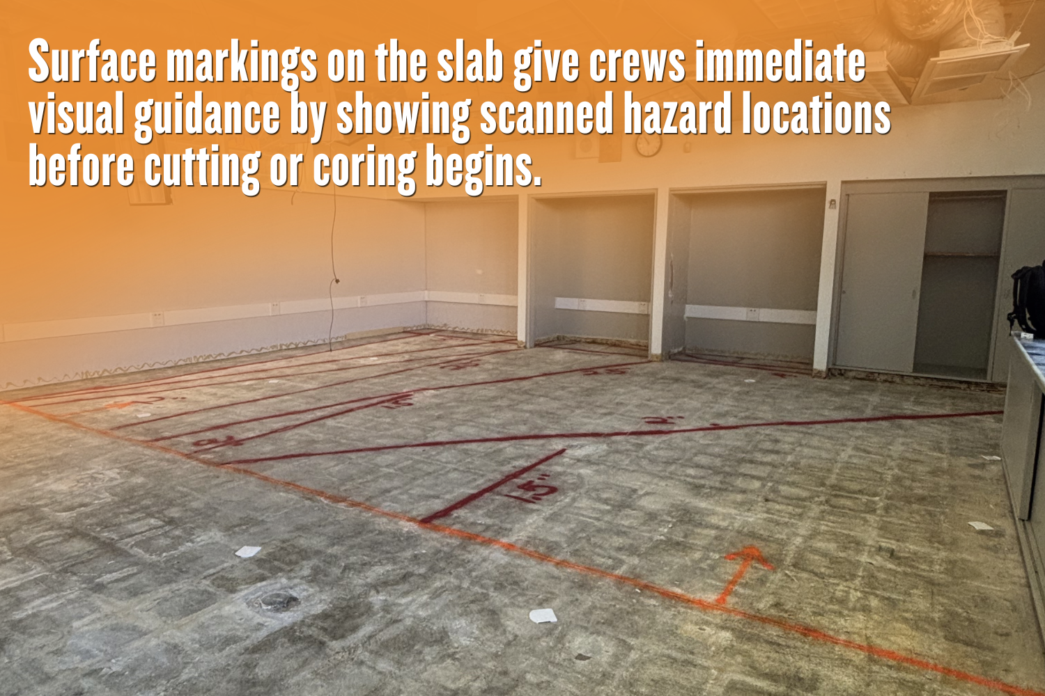
Surface Markings and Tape Layouts
Technicians use specialized tape and chalk to outline the exact location of embedded hazards directly on the slab surface. These temporary visual guides map out the precise locations of hidden subsurface elements. These physical boundaries show the drilling team exactly where they can safely cut. The layout provides an immediate map of the subsurface environment right beneath your feet.
Color-Coded Hazard Identification
Industry-standard color codes visually separate different types of hidden utilities and structural supports. Paint or tape in specific colors helps crews instantly differentiate between rebar grids, post-tension cables, and live electrical conduits. This universal color system prevents confusion. It keeps the cutting team fully aware of what lies below, minimizing the chance of an expensive mistake.
What Type of Digital Data Is Included in a Standard Report?
Physical marks eventually fade or get covered up by construction dust. Because of this, safety managers rely on documented proof of the GPR concrete scanning results for official compliance records. These digital files provide a permanent, easily shareable reference to the subsurface environment. They serve as a historical record long after the project moves to the next phase.
Raw GPR Radargrams and Cross-Sections
The digital report features 2D cross-sectional images to display the exact findings. These images, often called radargrams, show distinct hyperbola patterns that indicate the presence of hidden objects within the slab. Engineers review these raw visual representations to verify the field technician’s on-site interpretations.
Depth Estimations and Target Measurements
A standard report carefully logs the estimated depths of various anomalies found during the concrete scanning and imaging process. These target measurements give the drilling crew precise stopping points to avoid striking a critical element. Knowing the exact depth of a post-tension cable enables safe, shallow drilling when necessary.
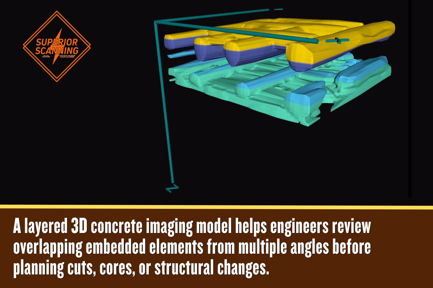
How Do Advanced 3D Maps Improve Complex Construction Planning?
Standard 2D scans are great for simple cuts. However, large structural modifications demand a more comprehensive view. Advanced 3D maps improve complex construction planning by providing design teams with a complete spatial view of dense, overlapping embedded elements. Standard concrete scanning services may lack the depth required for these massive overhauls. High-tech visualizations enable structural engineers to navigate complex subsurface layouts with complete confidence.
Interactive 3D Grid Renderings
Technicians stitch together multiple scanning passes to create a fully interactive 3D model of the concrete slab. This advanced rendering allows engineers to view the internal structure from different digital angles. Having a rotatable 3D view makes it much easier to plan safe pathways through heavily reinforced areas. Visualizing the slab in three dimensions eliminates dangerous blind spots during the planning phase.
CAD and BIM Integration Files
Top-tier services export spatial data into formats perfectly compatible with Computer-Aided Design and Building Information Modeling software. Bringing concrete X-ray data directly into a digital project model streamlines the entire design phase. Architects and engineers overlay the scanning results onto existing blueprints for flawless structural planning.
What Crucial Information Is Documented in the Final Written Report?
A comprehensive written summary from professional concrete scanning services serves as a vital liability shield and official project record. This final document is your proof of due diligence. It outlines the exact parameters and limitations of the inspection. You will find several specific details clearly outlined in this document to protect your team:
- Detailed scope of work and clearly defined scanned area boundaries.
- Specific equipment utilized, including antenna frequencies and calibration settings.
- Existing site conditions, such as high moisture levels or overly dense reinforcements.
- Limitations encountered during the collection of concrete X-ray or GPR data.
- Professional recommendations outlining the safest locations for drilling or cutting.
