
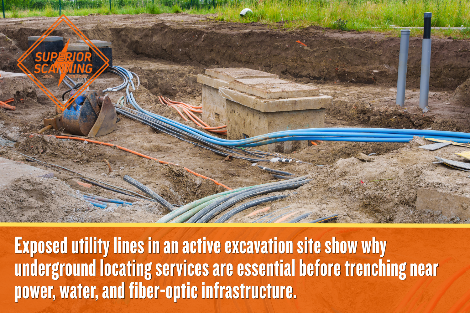
Digging into a new commercial trench without verifying the subsurface layout can lead to disastrous utility strikes and significant financial liability. Establishing a clear picture of the underground environment protects the site before an excavator bucket ever breaks the soil.
Booking a professional evaluation with Superior Scanning ensures your crew operates on precise data rather than dangerous guesswork. Advanced ground-penetrating radar (GPR) offers a highly accurate method to detect hidden hazards. This technology keeps the trenching project strictly on schedule and fully compliant.
Quick Glance: Why Contractors Use Ground Penetrating Radar Before Trenching
- Prevents utility strikes: Ground-penetrating radar (GPR) helps locate buried power lines, pipes, conduits, and fiber-optic cables before excavation starts.
- Reduces jobsite risk: GPR scanning provides crews with a safer trenching plan rather than relying on outdated drawings or guesswork.
- Protects the project budget: Finding hidden hazards early helps prevent emergency repairs, downtime, and costly change orders.
- Improves construction planning: GPR utility mapping gives contractors clear markouts and digital records for safer site coordination.
- Keeps trenching on schedule: A professional GPR survey helps crews confirm the subsurface layout before equipment breaks ground.
Table of Contents
Don’t Cut, Core, or Drill Blind
Superior Scanning is trusted on complex job sites
What Hidden Hazards Endanger Excavation Sites?
Undocumented infrastructure buried beneath the soil creates a major risk for any commercial excavation. Engaging professional underground locating services reveals specific subsurface obstacles before machines threaten your crew’s safety. Real-world construction sites often hide decades-old pipes and wires that require careful mapping.
High-Voltage Power Lines
Live electrical conduits often run at surprisingly shallow depths beneath concrete and dirt. Hitting these active cables creates an immediate electrocution risk for heavy equipment operators.
Pressurized Water Mains
Unmapped plumbing pipes can easily rupture under the brute force of a backhoe. Breaking a water main instantly floods the trench, causing extensive property damage and halting work for days.
Abandoned Fiber Optics
Old communication lines frequently cross commercial properties without appearing on any recent site plan. Severing these cables disrupts critical data networks for surrounding businesses and triggers massive repair bills.
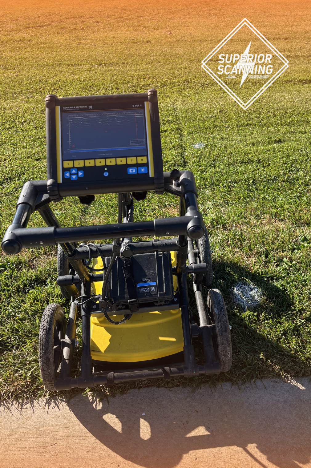
How Does the Scanning Technology Function?
This technology functions by transmitting radio waves into the earth to detect sudden changes in material density. A professional GPR survey uses specialized equipment to produce a highly detailed picture of the subsurface environment. The entire process relies on three specific technical steps to find buried objects accurately.
High-Frequency Radar Pulses
The machine emits radio waves directly into the ground as the technician walks the scanner across the site. These waves easily penetrate layers of soil, asphalt, and thick concrete to search for hidden structures.
Density Change Detection
The radar waves bounce back to the surface the moment a pulse hits non-metallic objects. This sudden reflection highlights variations in material density to clearly outline buried pipes or concrete vaults.
Instant Digital Analysis
The main control unit translates those returning signals into a real-time visual graph on a screen. This instant feedback allows the field technician to pinpoint the exact location of the buried anomaly.
What Makes Radar Better Than Blind Digging?
Radar beats blind digging because real-time data about buried utilities outshines outdated blueprints. Using GPR in construction workflows protects the entire site from costly mistakes. A thorough scan prevents accidental utility strikes during deep trench excavation while keeping project timelines moving forward without unexpected delays. You minimize emergency repair costs and protect field crews from life-threatening worksite accidents all at once.
Don’t Cut, Core, or Drill Blind
Superior Scanning is trusted on complex job sites
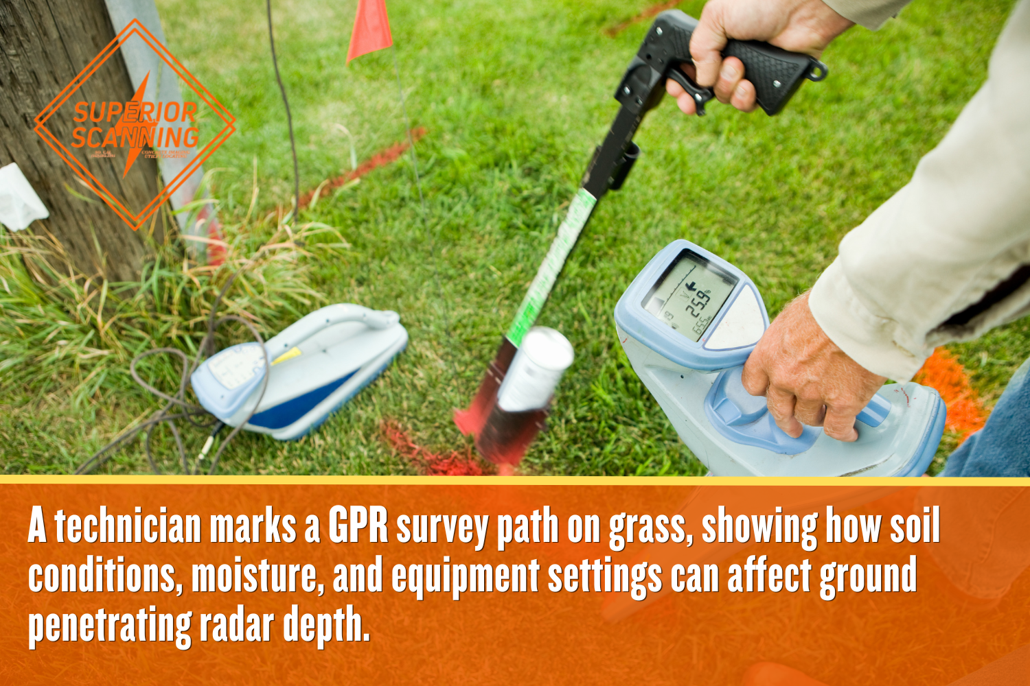
What Variables Impact Radar Scanning Depth?
Soil composition, antenna frequency, and ground moisture dictate the maximum scanning reach. Project managers constantly need to calculate ground penetrating radar depth to ensure the equipment clears the intended trenching zone. Several distinct environmental and technical factors influence how far the radar waves can successfully travel downward.
Local Soil Composition
Highly conductive soils, such as wet clay, absorb radar signals quickly and limit visibility. Dry sandy environments do the exact opposite by allowing for maximum depth penetration and clearer imaging.
Equipment Antenna Frequency
Lower-frequency antennas reach deeper into the earth but sacrifice some image resolution. Higher frequencies provide incredibly crisp details at shallow depths right below the surface.
Moisture and Water Saturation
Excessive groundwater scatters the radar pulses in unpredictable directions. This scattering makes it exceptionally difficult to detect anomalies accurately in flooded or heavily saturated conditions.
Which Deliverables Enhance Construction Planning?
Clear visual markouts and detailed digital maps enhance construction planning and coordination. Using professional GPR utility mapping turns raw radar data into practical tools your engineering team can use immediately. These precise records ensure that every trade works safely around buried obstacles throughout the build.
Direct Surface Markouts
Technicians apply color-coded paint and flags directly on the ground over the identified lines. These physical marks indicate the exact path of the buried utility for the equipment operators.
Digital Topographical Overlays
Comprehensive utility mapping services convert field markings into detailed computer-aided design files or GPS coordinates. These digital overlays provide a highly reliable reference for long-term project planning.
Permanent Utility Records
Detailed site documentation guarantees that future contractors have an accurate map of what sits below ground. These records remain incredibly valuable long after the initial trenching phase concludes.
Don’t Cut, Core, or Drill Blind
Superior Scanning is trusted on complex job sites
Frequently Asked Questions
What is a ground penetrating radar survey?
This non-destructive geophysical method uses radar pulses to image the subsurface to identify buried utilities and structural anomalies before excavation begins.
How accurate is ground penetrating radar utility locating?
When operated by a trained professional, the equipment is incredibly accurate and often pinpoints the exact location of buried pipes within a few inches.
Can GPR scanning detect non-metallic PVC pipes?
Yes, GPR scanning detects density changes to easily locate plastic polyvinyl chloride irrigation lines and empty conduits that magnetic locators miss entirely.
Does weather affect the scanning process?
Heavy rain and pooling water can severely limit the effectiveness of the radar because saturated soil naturally absorbs the signals.
How much does a ground penetrating radar service near me cost?
Pricing for a ground-penetrating radar service near you depends heavily on the site’s square footage, infrastructure complexity, and the required digital mapping deliverables.
How Will You Secure the Next Excavation Site?
Guessing the subsurface layout on a commercial trenching project inevitably leads to expensive delays and dangerous accidents. Superior Scanning provides fully insured scanning expertise for active construction and facility sites across Southern California, including Los Angeles, Orange, Riverside, and San Diego counties. We know construction schedules change rapidly. Flexible dispatching often accommodates next-day or same-week service requests to keep your build moving.
Pricing depends on the specific scope of work and can include competitive flat-rate or hourly rates based on your project details. Secure the site layout today and ensure your excavation crew digs with absolute confidence.
